Aboriginal and Torres Strait Islander readers should be aware that the article refers to people who have died.
Monday 3 September 1894, a quarter to five in the morning.
The barque has been lying hove-to since half past six last evening, her main yard braced aback so that she makes almost no way, her head pointed somewhere between west and west-north-west. The captain is asleep in the chart room on the poop. He turned in at nine, sure of his position: the patent log said Cape Moreton was abeam at half past four, and by his reckoning the light should be twenty-six miles to the west. At midnight the second mate told him everything was all right.
It is raining hard and blowing hard from the south-east. Two men are aloft on the foremast as lookouts. They cannot see ten yards.
Nobody has heaved the lead.
Sometime before midnight the wind shifted, and nobody woke the captain. The ship has been drifting all night with the land on her lee. The first mate, on watch since four, hears something through the rain that he thinks is breakers.
He calls the captain. The captain has barely reached the deck when she strikes.
Within a day there will be nothing left of the newest ship on the Queensland coast but a bowsprit, a stump of mast and two miles of beach strewn with salt, whisky and dynamite. Within a month a Marine Board will decide whose fault it was. Within four years the sea will finish what it started, and the beach itself will be gone.
Summary
The Cambus Wallace was a steel three-masted barque of 1,651 tons gross, launched by Russell and Co at Port Glasgow in March 1894 and classed at Lloyd's in April, the third of four "Cambus" ships owned through single-ship companies by Robert Russell and Co, shipowners and marine insurance brokers of Gordon Street, Glasgow[1][2][3]. She was 245 feet long and 37 feet 6 inches wide, with a female figurehead, and her master was William Anderson Leggat, who had held a British master's certificate for less than a year[1][4][5].
She left Glasgow on 3 May 1894 on her first voyage, bound for Brisbane with about 2,800 tons of general cargo, two-thirds of it salt, the rest whisky, beer, pig iron, paper, machinery and 1,200 cases of dynamite, and a crew of twenty-seven[6][7][8]. The passage took 121 days and was "one succession of gales": boats lost, the deckhouse stove in, the steering gear carried away and a jury wheel rigged from capstan bars[9][10]. She made the Australian coast on Sunday 2 September near the Solitary Islands and ran north all day in thickening weather[4].
At half past six that evening Leggat hove her to, believing Cape Moreton lay twenty-six miles to the west, and turned in at nine with orders to be called if the weather changed[4]. The wind shifted before midnight; the second mate did not call him; nobody heaved the lead; and the ship drifted all night towards a lee shore[4][6]. At about a quarter to five on Monday 3 September, just as the light came, she struck 200 yards off the ocean beach of Stradbroke Island at Jumpinpin, the narrow neck of sand near Swan Bay, and swung broadside to the surf[11][12]. Two boats were washed away at once and the others could not be launched[9]. A Swedish seaman, Gustav Kindmark, swam ashore and walked to the oyster camp at Currigee for help; the mail steamer South Australian stood by at eleven and could do nothing; the rest of the crew swam for it one by one through the day, and the captain and three apprentices came ashore in a swamped boat in the late afternoon[12][9][13]. By nightfall the newest ship on the coast was in pieces[9].
Six men died. The steward, Robert Birch, shut himself in his cabin and was never seen again; the carpenter, Thomas Smith, and the cook, Thomas O'Neill, were drowned at the last attempt to launch a boat; two able seamen, W. Patterson and D. McLaughlin, drowned in the surf; and Archibald Peebles, an old navy man, got ashore, wandered off, and died of exhaustion the next day aboard the government steamer Miner on the way to Brisbane[9][6][14]. Four bodies were buried in the sand under a pandanus tree on the Tuesday; Peebles lies in Toowong Cemetery[14][15]. Twenty-two men reached the beach, most of them naked, and were fed and sheltered by oystermen and yachtsmen who happened to be cruising nearby[9].
The Marine Board of Queensland sat for a week and found the master and second mate in default. Its printed finding blamed the ship's drift while hove-to, "the neglect to heave the lead", a southerly current for which no allowance was made, and "the master's absence from the deck at a time when his personal supervision was so essential"[6]. Leggat's certificate was suspended for two years, Henry Smithwick Martin's for six months, and the chief officer was censured[6]. Leggat replied in print that he had been "found guilty of more than I had any hand in", and the Board of Trade in London later shortened his suspension[16][17].
The cargo came ashore along two miles of beach and became, in Welsby's phrase, "an unbonded warehouse"[18]. What Customs could save was auctioned in Brisbane on 27 September; what they could not stop was dug out of the dunes and drunk in Southport for twenty years[19][20]. The water-damaged dynamite was blown up on the beach in the week before 24 September, throwing sand a hundred feet into the air[21]. The graves were fenced and marked with a boat's stern board and a piece of the ship's wheel, and later with a stone column paid for by public subscription[21][22].
The sand neck was already being eaten by the sea. On 8 and 9 May 1898 gales and abnormal tides cut a channel half a mile wide through it, beside the graves, which were washed away with their monument[23][24]. Stradbroke has been two islands ever since, and the channel is called Jumpinpin. Whether the dynamite helped is a story first told in print in 1929; nobody who was there in 1894, 1895 or 1898 told it[25][26].
The figurehead stood outside the Railway Hotel in Southport until 1929[25]. The wreck herself lies under the shifting sand of the Jumpinpin bar, where a magnetometer survey fixed her position in 2014; she is protected under the Underwater Cultural Heritage Act 2018[5][27].
Timeline
| Date | Event |
|---|---|
| 1894 | The steel barque Cambus Wallace is built by Russell and Co at Port Glasgow for the Cambuswallace Sailing Ship Company, Limited[12]. |
| 3 May - She leaves Glasgow for Brisbane on her maiden voyage with about 2,800 tons of general cargo, two-thirds of it salt, and 1,200 cases of dynamite; she sails finally from Lamlash on the Clyde (one source and a survivor say she towed out of the dock on 8 May)[9][28][10]. | |
| May to August - A passage of gales: boats lost, the deckhouse stove in, a seaman's ribs broken, the steering gear carried away and a jury wheel rigged[9][10]. | |
| Sunday 2 September - Landfall at daylight near the Solitary Islands, 121 days out; a poor noon sight; course altered west at 4.30 p.m.; hove-to at 6.35 p.m. waiting for the Cape Moreton light[4]. | |
| Before midnight - The wind shifts on the second mate's watch and the captain is not called[4]. | |
| Monday 3 September, 4.45 a.m. - She strikes 200 yards off the ocean beach of Stradbroke Island at Jumpinpin, near Swan Bay[4][12]. | |
| 3 September - Kindmark swims ashore and walks to the Currigee oyster camp; the South Australian stands by at 11 a.m. and cannot help; the news reaches Brisbane at 4.45 p.m.; the carpenter and cook drown in the afternoon; the captain and three apprentices reach the beach in the swamped port boat; the ship breaks up by nightfall[12][9][29]. | |
| 3 September, 9.30 p.m. - The government steamer Miner leaves Brisbane with the Shipping Inspector, police and provisions[9]. | |
| 4 September - The Miner reaches Swan Bay; the drowned are buried on the island; Archibald Peebles dies aboard on the way to Brisbane[9][28]. | |
| 5 September - The Courier prints its special report and an editorial blaming "erroneous navigation"[9][30]. | |
| 7 September - £30 subscribed; every man clothed; Customs seize a boat with eleven cases of whisky[31]. | |
| 10 to 19 September - The Marine Board inquiry sits in Brisbane[4][32][33]. | |
| About 11 September - Two brothers named Buckley fined £25 each for stealing spirits from the wreck[34]. | |
| Mid-September - The water-damaged dynamite is exploded on the beach by the Customs party; the graves are fenced and marked with a boat's stern board and a piece of the wheel[21]. | |
| 25 September - The Board's finding: the captain's certificate suspended for two years, the second mate's for six months, the chief officer censured[35][36]. | |
| 27 September - The hull, wreckage and salvaged cargo are auctioned at D. L. Brown and Co's wharf, Brisbane[19]. | |
| 28 September - Captain Leggat's letter: "found guilty of more than I had any hand in"[16]. | |
| 3 November - The memorial fund closes with £31 in hand for a monument and the widows[22]. | |
| 1895 | April - The wreck still visible; the neck of the island washing away; a channel predicted[26]. |
| July - The Board of Trade shortens Leggat's suspension at the request of the Scottish Shipmasters' Association[17]. | |
| A Southport photographer records the figurehead outside the Railway Hotel, where it had stood since the wreck[37][25]. | |
| 1898 | 8 to 9 May - Gales and abnormal tides cut the Jumpinpin channel through Stradbroke Island; the graves and memorial are washed away[23][24]. |
| 1914 | May - Part of a human skull found near Jumpinpin, thought to be a Cambus Wallace sailor[38]. |
| 1923 | 17 June - The figurehead photographed again at the hotel, paint gone and wood splitting[39]. |
| 1929 | February - Thomas Welsby publishes his recollection of the wreck with a photograph of the graves[15]. |
| October - The figurehead, outside Southport's Railway Hotel since 1894, is removed and found beyond repair[25]. | |
| 1931 | August - Bottles of whisky dug from the dunes near Currigee[40][41]. |
| 1950 | April - John Markey, "the only living survivor", sends his account from New Jersey to the South Coast Bulletin[10]. |
| 1971 | September - Ben Cropp photographed with items recovered from "the whisky wreck"; his museum later lists a silver tureen and bottles from her[42][43]. |
| 2006 | Jumpinpin Bar listed as a designated coastal bar under Queensland's marine safety regulation[44]. |
| 2014 | February - Queensland's Moreton Bay Shipwrecks map plots her at Jumpinpin; the national database records a magnetometer position the same year[45][5]. |
| 2019 | 1 July - The Underwater Cultural Heritage Act 2018 replaces the Historic Shipwrecks Act 1976 as the wreck's protection; no protected zone is declared for her[27][46]. |
| 1 September - The Marine Parks (Moreton Bay) Zoning Plan 2019 commences; the site sits on the boundary of Habitat Protection Zone 14 and Conservation Park Zone 10[47]. | |
| 2024 | 1 December - Lifejackets become compulsory for everyone in an open boat crossing Jumpinpin Bar[48]. |
The vessel
The entry in Lloyd's Register of Shipping for 1894–95, read from the page scan, says this[1]:
| Field | Value |
|---|---|
| Name | Cambuswallace (printed first as Cambus-Wallace, then corrected) |
| Official number | 102673 |
| Signal letters | NHTS |
| Master | W. A. Leggat, 1893–94 |
| Build | Steel barque, one deck, one cemented bulkhead |
| Tonnage | 1,651 gross; 1,590 net; about 1,532 under deck |
| Class | +100 A1, surveyed at Port Glasgow, April 1894 |
| Built | 1894 (April), Russell and Co, Port Glasgow |
| Owners | Cambuswallace Sailing Ship Co (Limited) (R. Russell and Co) |
| Dimensions | 245.0 ft long, 37.5 ft wide, 22.6 ft deep; poop 36 ft, forecastle 31 ft |
| Port of registry | Glasgow, British |
| Draught | 24 ft 0 in |
She was four months old when she sailed. The Scottish Built Ships database of the Caledonian Maritime Research Trust gives her launch as 14 March 1894 from Russell and Co's Kingston Yard at Port Glasgow, yard number 358[2]. No launch report has been found, so that date rests on the database alone. The register's "1894 4mo" and its survey date of April 1894 put her completion and classing a month later[1]. The Registrar's Appropriation Book, which allots official numbers, records her as Glasgow number 27 of 1894, a sailing vessel of 1,590 tons[49]. The Brisbane press, the day after she was lost, had her particulars exactly right: "a steel barque ... 1651 tons register, and was built by Russell and Co., at Port Glasgow, in the present year, so that this is apparently her maiden voyage"[12].
Port Glasgow, not Glasgow. The national shipwreck database gives her construction locality as Glasgow, and the State Library of Queensland's caption on her photograph says Greenock[5]. Both are wrong. Russell and Co built at Port Glasgow and at Greenock, but their head office was the Kingston yard at Port Glasgow, and the register and the 1894 press both say Port Glasgow[50][1][12]. Glasgow was her port of registry, which is a different thing.
Two firms called Russell. The database names her owner as "R. Russell and Co.", and that could be read as a slip for the builders, Russell and Co. It is not. The register prints the builder and the owner in separate columns: Russell and Co of Port Glasgow built her; the Cambuswallace Sailing Ship Company, Limited, managed by R. Russell and Co, owned her[1]. The Post Office Glasgow directory for 1894–95 lists "Russell, Robert, & Co., shipowners and marine insurance brokers, 8 Gordon st.", with Robert Russell himself living at Sardinia Terrace, Hillhead[3]. A single-ship company managed by a firm of shipowners and insurance brokers was the ordinary way to own a sailing ship in the 1890s. The Board of Trade's printed report of the inquiry, which condenses the two levels into "owned by R. Russell & Co.", is right as far as it goes[6]. Whether Robert Russell the owner was any relation of Joseph Russell the shipbuilder, who had left the yard in 1891, is not established[2].
A fleet named for river bends. She was the third of four. Russell and Co built the steel barque Cambusnethan (1,458 tons) for the same managers in 1891 and the steel ship Cambuskenneth (1,925 tons) in 1893, and the Cambusdoon followed in 1895, each owned by its own limited company[1][2]. All four names are Scottish places built on cambus, the Gaelic word for a bend in a river. Cambusnethan was wrecked near Algoa Bay in 1897; Cambuskenneth was sold to Norway and sunk by a submarine in 1915[2]. The Cambus Line's luck was not good.
The tonnages do not agree. 1,651 is her gross tonnage, the measure of her whole enclosed volume, and it is the figure in the register, the Board's report and the press[1][6][12]. 1,590 is her net or register tonnage, the earning space after deductions, which the Appropriation Book and the corrected line of the register give[49][1]. Captain Leggat told the Marine Board "1592"[4]. The 1,550, 1,560 and 1,600 of the first telegrams are round numbers[12][51]. The honest statement is: 1,651 gross, 1,590 net. Her beam was 37 feet 6 inches; the "32½ ft" in Welsby's 1933 article and in Markey's 1950 letter is a misreading that one of them caught from the other, or both from the same slip[18][10].
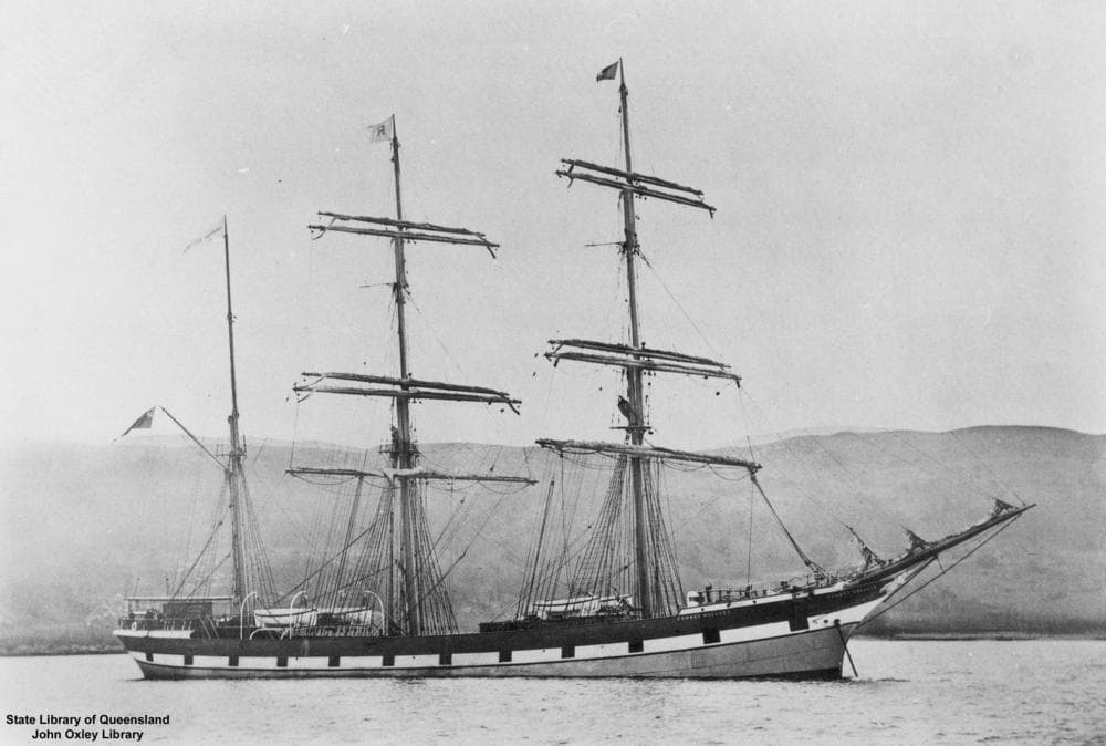
What she looked like. The State Library of Queensland holds a photograph of her at anchor, sails furled, three masts and a long bowsprit over a white-banded black hull, which is reproduced below. Markey, who sailed in her, described a "three masted barque with a steel hull, steel masts and yards, steel shrouds and back stays ... her only rope rigging was her running gear", carrying no royals or skysails but five square sails on fore and main, "stump top gallant masts", spanker and gaff topsail on the mizzen, and eight fore-and-aft sails[10]. Her figurehead, which survived her, was a female figure[5].
The master. William Anderson Leggat held a master's certificate of competency passed at Glasgow in October or November 1893, and had commanded ships from January 1891 to September 1893 on a Dutch certificate obtained at Java after the master of the British ship Woodville, in which he was mate, died there[4]. The register shows him as her master for 1893–94[1]. His officers were George Paul, chief officer; Henry Smithwick Martin, second officer; and William Stevens, third officer[6][9]. The press, as usual, spelt the captain Leggat, Leggatt and Legatt; the Board's print and the register say Leggat, and so does this page.
The maiden voyage
She left the Clyde in May 1894 and never saw land again until the Australian coast. The Brisbane press, reporting the wreck, said she had left Glasgow on 3 May with a full cargo for Brisbane[9]. Gustav Kindmark, the seaman who swam ashore, told the Southport telegraph office the same date and added that she had "sailed finally from Lamlash on the Clyde", the anchorage on the Isle of Arran where outward-bound sailing ships waited for a wind[9][28]. The Courier's first report gave 8 May instead[12], and so did John Markey, one of her seamen, writing from New Jersey fifty-six years later: "We towed out of Queens Dock, Glasgow on May 8th 1894 at 4 a.m."[10]. Both dates are probably right about different things: the day she left the dock and the day she finally sailed. The difference matters only to the arithmetic of the passage, and is left as it stands.
The cargo was the usual Glasgow merchandise, with two things that would matter later. About two-thirds of it, some 1,800 tons, was salt[9][7]. The rest was whisky, beer, pig iron, paper, machinery, cornflour, whiting, fish oil and general goods[9][52][19]. And there was dynamite: 1,200 cases of it, valued at £4,700[8][52]. The whole cargo came to about 2,800 tons[7][8]. It was consigned chiefly to Webster and Co of Mary Street, Brisbane, with parcels for Rockhampton and Bundaberg, and the ship's Brisbane agents were D. L. Brown and Co[15][52][8]. She was to have loaded wool in Brisbane for London[9].
Aboard were twenty-seven people and a dog. The master, three mates, a carpenter, a steward, a cook, four apprentices (three of whom had never been to sea), fourteen able seamen and two ordinary seamen[4][28]. The dog was a brown retriever pup called Bruce[10]. There were no passengers[12].
The passage was one long gale. For seven days after Lamlash the weather was fair; from the meridian of the Cape of Good Hope it was heavy "almost without intermission" until she went ashore[9]. Four heavy gales came in a single week[9]. A boat was swept from the fore deck, the fore lower topsail blew away, the iron deckhouse was stove in and a seaman, Westholm, had his ribs broken[9]. Markey remembered the steering gear carrying away, the poop skylight going, the starboard lifeboat "crushed to matchwood", the cabin swamped, and the carpenter rigging a jury wheel out of three capstan bars lashed together, with four men on tackles to the rudder quadrant to steer her[10]. "Not a dry spot on the ship, but we kept to our job," he wrote[10].
She made her landfall on Sunday 2 September. No land had been sighted since the Channel[9]. At daylight on the Sunday the captain saw the coast about where he expected it, somewhere near the Solitary Islands off the New South Wales north coast, 121 days out from the Clyde[4][9][18]. Brisbane was a day's sail away. The Courier put it plainly two days later: the ship "perished just when her crew were looking for the harbour lights"[30].
The night of 2 September
What happened between Sunday morning and Monday dawn is known in unusual detail, because Captain Leggat told the Marine Board hour by hour, under oath, a week later[4]. This section follows his evidence.
Sunday morning: a landfall and a fix. He sighted land at about daylight on Sunday 2 September and "made it exactly where he expected"[4]. At 6 a.m. he fixed the ship's position and estimated he was 35 to 40 miles off the land[4]. He did not see the land again after about 7 a.m.[4]. The wind was south-east, a moderate breeze, and he steered north, true, making five to six and a half knots[4].
Noon: a poor sight. At noon he took an observation that put him 38 miles south of Cape Moreton and 35 miles off the land[4]. It was "not a first class one": it disagreed with the patent log, the towed instrument that measures distance run, by twenty miles[4]. From noon to half past three the weather was thick and rainy, and the crew "fancied that they could see the land occasionally, bearing about west"[4]. He was shortening sail all afternoon as the wind freshened[4].
Half past four: the turn to the west. By the patent log the ship was abreast of Cape Moreton at 4.30 p.m., so he altered course to true west, under foresail, lower topsail and a main topmast staysail only[4]. He held that course for about two hours, reckoning six or seven miles run, and at 6.25 p.m. believed Cape Moreton lay 26 to 28 miles due west[4]. At half past five, when the weather cleared a little, he sent the second mate to the topsail yard; the mate thought he could see land "but very faintly"; the captain looked several times and could not[4].
Half past six: hove-to for the night. He hove the ship to, backing the main yard at 6.35 p.m. with the fore yard braced sharp up on the port tack, so that she lay with her head pointing west, west by north and west-north-west in a southerly wind, making as little way as possible[4]. He "fully expected to pick up the light when it was lit", meaning the Cape Moreton light[4]. He gave orders to be told of any change in the weather, but gave no order to heave the lead, the weighted line that measures the depth of water: he "did not think there was any necessity", being "convinced that he was outside the line of soundings"[4]. A seaman and the third mate were on lookout on the topgallant mast until nine o'clock, and a seaman all the rest of the night[4]. The seamen on lookout later said the night was dark, raining and blowing, and that they had been told to look out "for light and land"[32][33].
Nine o'clock: the captain turns in. He lay down in the chart room on the poop, with the chart on the table where his officers could use it[4]. At midnight the second mate called him and "told him everything was all right"[4]. It was not. The wind had changed before midnight, during the second mate's watch, and he had not reported it[4]. The chief officer had the watch from midnight to four; the second mate came on again at four[4].
Four o'clock: heading the wrong way. At 4 a.m. the mate told him the ship was heading south to south-south-east, close hauled[4]. The captain then knew the wind had shifted, "but seeing it was close on daylight he did not think of doing anything"[4]. He did not try to work out how much leeway she had made since nine the night before[4]. The mate said he did not think she was drifting[4]. "He was too sure of his position being so far off to take much notice of it," the Courier's reporter wrote, summarising his evidence[4]. He knew there was a southerly current on this coast but did not think he was in it[4].
The chief officer's watch. George Paul, who had the deck from midnight to four, told the Board that "there was no change in the heading of the ship during witness's watch", that he did not hear the breakers, that the patent log was in the water all night, and that he "did not think about heaving the line over. It was all ready for use, but he did not consider that it was necessary to use it"[53]. He thought a ship hove-to as she was might make nine or ten miles of leeway[53]. Nine or ten miles, on a ship believed to be twenty-six miles off the land, with the wind now on the shore, was the margin.
A quarter to five: breakers. The able seaman Charles Watson, who came to the wheel at first light, saw the second mate "looking at something white on the starboard side", asked what it was, and was told "it could not be breakers, and must be a shoal of fish"[11]. Sent up the mizzen rigging, Watson saw breakers and sang out; the second mate went below for the captain; the captain came up and ordered the lead line, "but before the latter had time to do anything she struck aft, and the captain said, 'The ship's ashore'"[11]. The land could not be seen, only the breakers[11]. The second mate called him at 4.45 a.m.[4]. In the crew's account given to the press, it was the mate who "told him that in his opinion they were near the breakers", and "the captain had barely time to come on deck before the vessel struck"[9]. She was going close hauled under close-reefed topsails and foresail, in weather so thick the lookouts "could not see ten yards ahead"[12]. Kindmark, at the wheel earlier in the night, said that when she struck "the wind was blowing right on the land"[32].
Asked how he came to be there, Leggat "had no idea how he got ashore where he did, as he reckoned he was outside the channel altogether"; the only reason he could give was "the strong inset which he had not noticed so strong before"[4]. The chart he was using, the latest Admiralty coast sheets, was lost with the ship, along with his certificate, the log book and all the ship's papers, which he had put in the chart room to be ready to grab; the chart room was stove in[4].
The wreck
She struck bow first, then swung broadside to the sea. The able seaman Murdoch Macaulay, who was on deck, said the ship struck with her bow first and took about twenty minutes to slew round[33]. Within minutes the sea was making a clean breach over her, "dashing in spray half-way up her masts"[12][9]. She lay broadside on, about 200 yards from a beach of clean hard sand, with 200 yards of breakers between[12]. The place was the ocean side of Stradbroke Island near Swan Bay, at the narrowest point of the island, which boating people called Jumpinpin, or Tuleen, or Duleen[12][26]. The steamer South Australian, passing at eleven that morning, put her fifteen miles south of Point Lookout[12]; the Southport correspondent put her fifteen to twenty miles north of Southport[9].
The boats went almost at once. Two of the four boats were washed away by the first seas[12]. The crew tried to get the starboard lifeboat out, but a sea stove it in; they then tried the port lifeboat, but by then the ship was heeling so far to starboard that it could not be launched[9]. Macaulay told the Board that if the boat tackles had been kept hooked on, instead of lashed to the davits, the boats could have been got over quicker, and "none of the crew would have been drowned"[33]. That is one seaman's opinion and was not adopted by the Board.
The captain gave the men leave to swim for it. Kindmark, asleep below when she struck, remembered "hearing the captain tell all hands that they could try and save themselves by swimming ashore if they chose to risk it"[9]. Markey remembered the crew gathered in the mizzen rigging as the foremast and mizzen topmast went, shouting "duck" at every sea that broke over them, and laughing at it, until the hull began to break up and the hatches burst and they watched their cargo "being whipped ashore on the top of the seas"[10]. The dog went ashore before any of them: "our poor pup named Bruce was washed ashore, a brown retriever, I saw him on shore afterwards but he would have nothing to do with any of us. I suppose he thought we had done a dirty trick on him"[10]. What became of Bruce after the beach, nobody recorded.
A line to the shore: the attempt that nearly hanged a man. A couple of hours after she struck, the seaman John Reid volunteered to swim ashore with a line, with Kindmark to help haul it in from the beach[9]. Half-way across Reid was struck by wreckage, the line fouled round his neck, and he was hauled back aboard unconscious[9]. Markey, who helped recover him, said the only line they had was part of the signal halyards, and that "he was almost hanged"; they held him in the rigging and gave him what artificial respiration they could[10]. Kindmark, meanwhile, lowered himself into the breakers by a rope, touched bottom several times, was swept off his feet repeatedly, and was finally "cast ashore by a huge roller in a very exhausted condition"[9]. He was the first man ashore[12].
The long day in the rigging. The captain, the carpenter, the cook and the four apprentices took to the mizzen rigging; others stayed on the poop and swam for it as chances came[9]. About midday the first mate, George Paul, was washed overboard, badly cut by wreckage, and got ashore[9]. About four in the afternoon the mainmast went over the side, and a falling topsail brace struck the captain on the head and knocked him out of the rigging onto the deck[9]. He climbed back, saw the fore and mizzen masts beginning to bend, and decided to try the port lifeboat once more[9]. He let go the forward tackle so that the boat fell alongside, held only by its painter[9]. As the men prepared to jump in, the carpenter, Thomas Smith, was washed off and drowned[9]. One of the boys was washed off too, but was a good swimmer and reached the beach[9]. The cook, Thomas O'Neill, jumped, missed the boat and floated away; his body came ashore later[9]. The three remaining apprentices got into the boat, the captain cut the painter with an axe and jumped in after them, and the swamped boat drifted to the beach, where men who had already landed seized it[9]. "The captain stated that on reaching the shore he was totally unconscious, and did not regain his senses till early the following morning"[9].
By the afternoon there was almost nothing left. "Within twelve hours practically went to pieces," the Courier's special reporter wrote; by Tuesday afternoon "only the bowsprit, a portion of the stem, and a few broken timbers were to be seen"[9]. The South Australian, which had stood in to within a quarter of a mile that morning and found the sea too heavy to launch a boat ("to launch a boat would have been folly"), watched the mainmast go overboard while she waited, and steamed on to report at Cape Moreton[29][54]. The chief officer thought afterwards that she might at least have tried a lifeboat to leeward, and said so to the Board without meaning to reflect on her captain[53].
Three weeks later a visitor found "the forecastle and bowsprit remain, with the foot of the foremast. The middle of the hull is out of sight, but the vessel's sternpost is visible"[21]. The editorial verdict was that she was "fresh from the builders' hands" and yet "unable to withstand the impact of the waves"[30]. Markey, who had sailed in her, disagreed: "She was very strongly built which she later proved"[10]. A steel hull on an open ocean beach in a south-east gale does not get the chance to prove much.
Twenty-two ashore
Kindmark's walk. From the beach there was no settlement in sight, but a few miles south on the bay side lay the oyster fishers' camp at Currigee[12]. Kindmark reached it, whether by seeing it from the masthead before he jumped or by "some happy chance" finding the track across the island nobody then knew[12]. People from the camp took him by boat to Southport, where at 7.50 p.m. the telegraph manager wired Brisbane: the barque Cambuswallace, 1,600 tons, Glasgow to Brisbane, ashore near Swan Bay between four and five that morning, crew about twenty-seven, no passengers, two boats gone, the men on the poop with the lower decks full of water, and "a large quantity of dynamite on board"[12]. Welsby, who was there within forty hours, later wrote that "kind-hearted oyster men, coloured men as well as white, were soon back at the scene of the wreck"[18]. He does not name them, and nothing read for this page says who they were.
Hospitable fishermen. When the men were mustered on the beach, twenty-two had reached the shore, "nearly all in a totally nude condition"[9]. Help came from a party of Bay men who happened to be cruising nearby: J. S. Stevens, manager of the Moreton Bay Oyster Company, with C. Tripconny, S. Lord, K. Islin, A. Joyce and E. Hage[9]. They pitched a couple of tents and gave the sailors all the food they had[9]. Markey remembered it more simply: "We were all very hungry and cold. We dug holes with barrel staves in the sand and slept"[10]. The Gympie Times reported that the captain's only clothes were "a pair of trousers with one leg"[8].
The news reaches Brisbane, slowly. The South Australian had signalled the wreck to Cape Moreton at about 4 p.m. on the Monday, and the Cape wired the Port Office at 4.45, after the department's officers had gone home for the day[9][12]. The Portmaster, Captain T. M. Almond, wired Dunwich and Southport to send what help they had, and ordered the government steamer Miner down with Captain Fison, the Shipping Inspector, provisions, "whatever appliances experience could suggest" and a party of police to guard the cargo[12]. The Miner left the Port Office wharf at half past nine that night under Captain Gruer, picked up Inspector Wassell of the Water Police and two Customs officers at Lytton, anchored off Cleveland because the beacons could not be seen, and threaded the island channels at first light to anchor off the entrance to Swan Bay[9]. Two boats went up the passage to Jumpinpin and found the crew dressed in whatever material they could find, "and even then some of them were almost half-naked"[9].
A row about the delay. Passengers off the South Australian, reaching Brisbane at 9.30 that night, were "rather astonished" to find a government steamer only then leaving, and more astonished to find that the harbour-master, Captain Mackay, had not been told of the wreck at all and had gone to bed[9]. The Portmaster explained that no time had been lost: the wire reached an empty office, the secretary took it by cab to his house, the Miner could get no further than Coochiemudlo before daylight anyway, and the interval had been spent raising her crew and steam and loading provisions[9]. The Courier thought the ignoring of the harbour-master "of too astonishing a character to be passed over", and connected it to "the unhappy relations" between officers of the marine service[30]. Captain Leggat, three weeks later, was blunter: a few men came at midnight with "a few matches and a little tea", the Miner arrived next day with nothing that would have helped anyone still on the wreck, and the relief "was a complete farce as far as the port authorities of Brisbane were concerned"[16].
Home to Brisbane. The Miner took the survivors up to town on the Tuesday, meeting the Pippo at the Pile Light bringing Customs men down to the wreck[9]. Three men went to hospital: the third mate Stevens, the seaman Mathers and the first mate Paul; Mathers was discharged, the other two kept in[9]. Markey remembered "quite a crowd of people at the pier to welcome us, some crying at our pitiful sight"; a Mrs Morrison of Edward Street, who asked if there were any Glasgow boys among them, took him home, and the rest went to the Shamrock Hotel[10]. Next day every man was fitted out with new clothes[10][31].
Those saved
The Queenslander printed the photograph above, with portraits of the four officers and of Kindmark, "the man who first swam ashore", and named the men in the group[55]. The Courier had printed the names on 5 September[9]: Captain W. A. Leggat; George Paul, first mate; Henry Martin, second mate; W. Stevens, third mate; the able seamen C. Alson, G. Mathers, Gustav Kindmark, F. Westholm, Vladimir Madison, F. Frederickson, Jack Bryce, Charles Watson, Peter Kennedy, Murdoch Macaulay, John Markey, Alexander Brandt and John Reid; and the apprentices W. Muir, John Patterson, J. Finlayson and Walter Neilson[9]. The spellings wander from paper to paper (Kindmerk, Madison, M'Aulay, Brandt and Brand), and "Vladimir Madison" is almost certainly the Waltman Matson who gave evidence at the inquiry[32]. One of the apprentices, Patterson, shared a surname with one of the dead. The Week listed John Markey as the ship's ordinary seaman rather than an able seaman, and added that the crew, "unusually well fitted out and supplied with clothing", had "lost everything they possessed": the captain his chronometer, his instruments, his books, and the cabin he had furnished at his own expense "to make it a home for himself", and he "came ashore without a hat or a shoe"[56].
The six who died
Six men died. Five drowned or were killed in the surf; one died afterwards of exposure. The Courier listed them on 5 September: R. Birch, steward; Thomas O'Neill, cook; Thomas Smith, carpenter; W. Patterson, A.B.; D. McLaughlan, A.B.; and A. Peoples, A.B., "died from exhaustion"[9]. The Gympie Times called Patterson and McLaughlin seamen drowned "whilst trying to leave the ship", and Peebles an ordinary seaman[8]. The database spells the sixth man Peeblea and the cook Thea. O'Neil: the first is an OCR error for Peebles, the second a misreading of Thos.[5]. The seaman Alexander Brand told the Board that some of the dead "appeared to have been struck by the wreckage, as there was blood on their heads"[32].
The steward who would not leave his cabin. Robert Birch was in his cabin fixing a lifebelt when a seaman warned him to come on deck because the ship could not hold together; "his reply was inaudible", he shut the door and refused to leave[9]. Markey, who went into the cabin with the second mate to get him out, remembered him "holding the bible in his hand"[10]. Welsby heard that when warned, "the steward laughed"[18]. On 5 September his body had not been found[9]; Welsby, writing in 1933, said it was found above high-water mark on the Monday afternoon[18]; Markey wrote "his is a steel casket"[10]. Which is right cannot now be settled, and the point is left open in Gaps and uncertainties.
The carpenter and the cook died in the afternoon in the attempt to launch the port boat, as told above[9]. Markey found the carpenter, "Chips", on the beach next morning, "badly smashed about, he must have been killed coming ashore amongst the cargo"[10].
Archibald Peebles, the old man-of-war's man. Peebles got ashore safely and seemed well, then wandered off alone; he was found next day on the beach "all but dead" of exhaustion[9]. Welsby adds that he had been hurt among floating timbers while swimming ashore and was found lying near the body of a comrade[15]. He was carried to the Miner, wrapped in blankets, and died on the way up to Brisbane, off Cleveland[9][18]. He had once served in the navy[15]. He was buried in Toowong Cemetery[15][18].
The graves on the beach. The bodies of the drowned were buried on the island. The Miner's party had meant to bring them to town, but Dr Brockway had come up from Southport with Sergeant Murray to give the certificates, so they were buried where they lay[9][14]. The Week's reporter counted them: "Four dead bodies were lying together a little way from the camp; and after Dr. Brockway had examined them, it was resolved, with Captain Leggat's consent, that they should be buried in the sand. A place was accordingly selected under the shadow of a native breadfruit tree, and there reverently, although hastily, the four seamen were laid"[14]. The Sydney papers said the same: all the bodies except Birch's recovered "and were buried on the island to-day", Tuesday 4 September[28]. The Board's finding agrees: four "either drowned or killed by floating wreckage", and the steward "supposed to have been drowned in his cabin"[6]. Welsby, who came down in the yacht Undine with the underwriters, remembered it as five: "we laid the bodies of the five sailors to rest on the sandy hill top, overlooking the ocean", under two pandanus trees[18]. He was writing thirty-nine years later. Four graves is the contemporary count, and the steward's body was not found by the time the papers stopped reporting it. Markey, who was there, wrote simply: "We buried their bodies the following morning at the foot of a clump of trees"[10].
The memorial. Three weeks later the graves had been fenced with a substantial railing under the direction of Captain Wallace, with hillocks of sand marking the resting places[21]. In the centre stood the stern board of one of the ship's boats, lettered "Cambus-wallace, Glasgow", surmounted by a segment of the ship's wheel, which had come ashore in pieces: "so far the only epitaph"[21]. A memorial fund raised by a concert and subscriptions had £31 2s 6d in hand by November, of which £10 or £15 was to be spent on a monument and the balance sent to the widows[22]. Welsby, who stood "with uncovered head" by that railing many times, described the finished grave in 1929: the railing, a headstone, and the piece of the wheel at the right-hand corner, looking north across Swan Bay to the hills of Stradbroke[15]. A photograph he published in 1907 shows the stone column that the memorial fund paid for, with the boat's stern board and the wheel behind it; the inscription carries six names, so Peebles, buried in Brisbane, was remembered with the five who died at the wreck[57]. What happened to it is told under The sea breaks through.
The Marine Board inquiry
The Board sat within a week. The Marine Board of Queensland opened its inquiry on Monday 10 September 1894 and heard evidence on five days, to 18 September, with counsel's address on the 19th[4][33]. The Portmaster, Captain T. M. Almond, took the chair, with the Hons F. H. Hart and E. B. Forrest, Captain Taylor and Mr J. D. Campbell sitting with him as attendance allowed[4][32]. Mr Arthur Feez, instructed by McPherson and Feez, appeared for the captain[6]. Leggat later complained that he had been served with "a statement completely wrong" and a summons on the Friday night at twenty to nine, under a £50 penalty to attend on the Monday, leaving "a few hours on Saturday to instruct anyone in my defence"[16].
The captain's evidence took the first two days and is set out above under The night of 2 September. Three further things he said matter here. He held a master's certificate passed at Glasgow in late 1893, and had commanded ships from 1891 to 1893 on a Dutch certificate obtained at Java when the master of the British ship Woodville, in which he was mate, died there[4]. He had an uninsured interest in the ship, a few hundred pounds of shares in the single-ship company that owned her, and would lose about £150 in money and effects besides[53]. And he had not been to bed since 2 May: "never slept without his clothes", always lying down in the chart room "to be handy for calling", on "the worst and the most anxious" passage of his life in a ship he described as "very slow and very wet"[53].
The officers and seamen. The chief officer, George Paul, aged 31 and holding a master's certificate, was heard out of turn on 11 September because he had been offered a passage home as third mate of the Gulf of Lions, sailing that day; he said he had never sailed with a more careful navigator than Captain Leggat, that the lead "was all ready for use, but he did not consider that it was necessary", and that in his own watch, midnight to four, "there was no change in the heading of the ship"[53]. The third officer, William Stephens, on his first voyage as an officer, called Leggat "the most careful he had ever sailed with"[11]. The seamen Watson, Brand, Kindmark, Matson, Westholme and Macaulay followed, and their evidence on the lookouts, the "shoal of fish", the boat tackles and the ship's handling is given in the sections above[11][32][33]. Leggat, recalled, said he had complained to the second mate since coming ashore "of his having neglected to call him when the wind shifted on Sunday night. The mate certainly neglected to carry out his orders"[33].
The finding, 25 September 1894. The Board's Report and Decision survives in print, because the Board of Trade in London reprinted colonial wreck inquiries, and this one is Wreck Report No. 5018[6]. After a narrative of the voyage and the night that follows the captain's own evidence, the Board found[6]:
The charts, log-books, deviation cards, and time azimuth books were lost; and they are consequently unable to say whether the position of the ship was accurately found on the two days preceding the wreck, and whether the corrections for the compasses had been properly applied.
The position of the "Cambuswallace" should have been verified before she was hove-to with her head in shore at 6.30 p.m. on Sunday, 2nd September. No measures were taken to ascertain her position afterwards. Considering the state of the weather and the proximity of the land, the action of the master was most unseamanlike in allowing the vessel to remain with her mainyard aback until she struck at 4.50 a.m. the following day (ten hours) without taking a cast of the lead, and in paying no attention to the change of wind reported by the chief officer at 4 a.m., or attempting to find the course and distance she was making.
The casualty is attributable to the forereaching and leeway made by the vessel when lying-to, the neglect to heave the lead, to the prevailing southerly current (for which no allowance was made), and to the master's absence from the deck at a time when his personal supervision was so essential for the safe navigation of the ship.
The Board found the master and second mate in default, called on them to show cause, heard that they "had nothing further to advance in their defence", and suspended William Anderson Leggat's master's certificate for two years from 3 September 1894 and Henry Smithwick Martin's second mate's certificate for six months from the same date[6]. The chief officer, George Paul, "having failed to take a proper interest in the navigation of the vessel on the night of the 2nd September 1894", was censured[6]. The Board recommended that Leggat be granted a first mate's certificate for the period of his suspension[6]. The decision was telegraphed round the colonies the same day[36][35].
A conflict that is not one. The crew list of 5 September names the second mate Henry Martin, the Sydney Daily Telegraph calls him "Mr. Martin", and Melbourne's Argus calls him "Henry Smithwick"[9][36][35]. The Board's print gives his full name, Henry Smithwick Martin, and the Argus telegraphist simply dropped the surname[6].
The captain's reply. Leggat answered in a letter the Courier printed on 28 September[16]. The judgment had appeared in Wednesday's papers, so the reporters had it on Tuesday; he did not receive it until noon on Thursday: "They condemn a man and do not tell him"[16]. He objected to the chairman pressing a sworn witness to "guess" how far the ship had been off the land[16]. And he put his own case in a sentence: "the ship was not in sight of land at 6 p.m., when the weather was clear, and she was ashore before daylight, the ship during that short time being hove-to, with her head part of the time towards the land, and part of the time with her head off the land. It seems to me I have been found guilty of more than I had any hand in"[16].
He had a point about the current: the Board itself listed "the prevailing southerly current (for which no allowance was made)" among the causes, and no chart could have told him how strong it ran that night[6]. He had no answer on the lead.
London had the last word. In July 1895 the Brisbane press noted that "the Board of Trade has shortened the time of suspension of the certificate of the late master of the barque Cambuswallace, at the instigation of the Scottish Shipmasters' Association"[17]. By how much, it did not say, and no Scottish or Board of Trade record of it has been found for this page. What became of William Leggat afterwards is not known from anything read.
Salt, whisky and dynamite
An unbonded warehouse two miles long. By the Tuesday afternoon "cases of spirits, salt, dynamite, and large pieces of wreckage" were strewn along the beach for about two miles, and Customs officers were already "doing their best to prevent a repetition of the thefts which were so painful a feature of the Scottish Prince wreck lower down the coast"[9]. They did not wholly succeed. Within days the tide surveyor, Mr Wassell, and a landing waiter captured a boat with three men and eleven cases of whisky "supposed to have been picked up from the wreckage"; the men were taken to Southport for prosecution[31]. Two brothers named Buckley were fined £25 each for stealing spirits from the wreck[34]. Welsby, whose firm handled the salvage, wrote forty years later that the outer shore of Stradbroke "became an unbonded warehouse - for any and everybody", that much "perishable" cargo disappeared under the eyes of the Customs officers with no duty paid, and that Currigee, "a thickly-populated oyster camp" in 1894, meant "the Southport Hotels were not the only places to quench a thirst"[18]. A correspondent signing himself "Ajax" recalled in 1933 that whisky from the wreck was on sale in Southport and along the railway as far as Beenleigh "for many years", buried in the sand by publicans and fisher-folk, and was "the bane of the Customs officers' lives for a couple of decades afterwards"[20]. Bottles were still being dug out of the dunes near Currigee in 1931[40][41].
The salt went up in price. The loss of 1,800 tons of coarse salt and 56 tons of rock salt "had the effect of increasing the price of salt quite 10s per ton" in Rockhampton within the week[52]. The same report itemised what else had gone down: £4,700 worth of dynamite, 220 tons of pig iron, 34 tons of whiting, 7,330 gallons of bulk spirits, 5,370 cases of spirits and £610 of cornflour, "a good deal of the liquor" consigned to a Rockhampton house[52]. Bundaberg was expecting mill machinery and a large supply of salt from her[8]. The insurance was mostly placed in Britain; the eleven local companies held small lines, except the Reliance at £2,000[9][7].
The auction. On Thursday 27 September G. T. Bell, the Government Auctioneer, sold at D. L. Brown and Co's wharf in Eagle Street first "the Hull, Wreck, and Wreckage of the ship Cambuswallace, as she now lies stranded off Stradbroke Island", and then the salvaged cargo, in bond: 64 hogsheads of beer, 52 quarter-casks and 34 octaves of whisky, 870 cases of whisky, 50 cases of Usher's Special, 85 casks of fish oil, chloroform, castor oil, kippered herrings, printing ink, and 86 bales and 10 cases of paper, "the whole of the spirits" to be "gauged and tested and quantity and strength guaranteed at time of sale"[19]. The next day's notice added a lifeboat, four fenders, spars and timber, and more paper[58]. The spirit trade in Brisbane went quiet that week; buyers were "holding off in anticipation of the sale of the salvage"[59]. The whisky brands on the auction list are a roll-call of 1890s Glasgow: Teacher's, Buchanan's, Bulloch Lade, Usher's, Highland Nectar, Thom and Cameron[58].
The dynamite. Twelve hundred cases of dynamite had been in the hold[8]. It came ashore with everything else, and seawater made it "highly dangerous"[21]. It was not sent to Brisbane. In late September two Brisbane cyclists, H. Henderson and H. Hirsch, who had ridden to Coomera and sailed to Jumpinpin to photograph the wreck, were sheltering from a squall in the tent of Captain Wallace and Mr Eyre of the Customs when "a terrific explosion nearly deafened us"[21]. They went out to watch the next one: "The little busy knot of people engaged in the destruction dispersed rapidly, and soon there was an awful report. Sand was raised to a height of about 100 feet, and some of it, being carried over the land by the strong wind, fell in the bay like a heavy shower of rain"[21]. That is the only eyewitness account of the destruction of the dynamite found for this page. It says where it was done (at the wreck site, within sight of the graves), who was in charge (Customs), and roughly when (the week before 24 September). It says nothing about craters, dunes or the sea.
The relief fund and the men afterwards
Brisbane paid for their clothes. Captain Fison opened a subscription list on the Miner on the way back to town, headed by Inspector Wassell, and when the Otter passed them in the river her captain, South, took a collection from his passengers too[9][60]. The Governor, Sir Henry Norman, sent £10 unasked with his compliments; the Portmaster gave £1; ferry passengers gave shillings[60][58]. On the island, Tripconny and two local justices, Lord and Fowler, had fed the men on beef and bread before any official arrived[60]. By 7 September £30 was in, each man had a complete suit of clothes, and Mr Fison was suggesting that "ladies who have the leisure" might make up a kit for the apprentices, who had no wages coming to them[31]. By 14 September the fund stood at £105 with thirty-three lists still out, and had spent £35 on clothes, £21 on half the apprentices' passage money home in the Gulf of Lions, £5 to the mate, who was going home in the same ship, and 25 shillings to each of the fifteen sailors[61]. A benefit at the Opera House, organised by an old sailor who kept a cigar shop at the foot of Queen Street, with doorkeepers in sailors' costume, was "a full success"[20]. The separate memorial fund is described above. Of about £150 raised in all, £12 was sent to the Glasgow Sailors' Home for the widows of the cook and the steward, with a little extra to advertise for them in the Glasgow papers; the superintendent passed it to the Mercantile Marine Office, which passed it to the Board of Trade "asking for instructions", and the Brisbane Observer wondered in January whether the widows would ever see it[62].
Southport took them in. The youngest sailor aboard wrote to the Brisbane Telegraph in 1929 that he had been in many wrecks since, "but nowhere had he received more kindness than in Southport, where the people took the stranded sailors into their homes, and fed and clothed them"; he was by then happily married in America[25].
John Markey went straight back to sea. After a few days he shipped in the steamer Duke of Sutherland for London via New Zealand and was home in Glasgow "after 7 months of a licking"[10]. Two weeks later he joined the full-rigged ship Port Errol for Adelaide and Melbourne with "the same cargo as the Wallace"; she caught fire at Lamlash and was a total loss before she had left the Clyde[10]. In 1950, from Arlington, New Jersey, he sent the South Coast Bulletin at Southport the story of the wreck as he remembered it, believing himself "the only living survivor"[10]. His account, written fifty-six years on, gets the weekday wrong and some of the sequence muddled, but it is the only account by one of the crew that is more than a telegram, and it is the only source for the dog, the jury wheel, the second mate's attempt to reach the steward, Mrs Morrison of Edward Street and the barrel-stave beds in the sand.
The sea breaks through
In 1894 Stradbroke was one island. It ran 38 miles from Amity Point in the north to Porpoise Point opposite Southport, and its narrowest part, near Swan Bay about fifteen or sixteen miles from the southern end, was the place boating people called Jumpinpin, or Tuleen, or Duleen[18][26]. The wreck lay on the ocean side of that neck[18]. A photograph in the Queensland State Archives shows what it looked like a few years before: a low, bare strip of sand with the bay behind it.
What the name means. Welsby twice gave the meaning of Jumpinpin as "big fellow wave", in "native language", without saying whose[15][18]. A better-sourced account appeared in 1921, when Isobel Hannah of Southport wrote up the island's history for the Courier. "It has been stated that the native meaning of Jumpin Pin is 'Breaking Wave'", she wrote, but Mrs Graham, the widow of Andrew Graham the Southport lightkeeper, "asserts that in the dialect of her mother's people 'Jumpin Pin' signified 'eating honey with suckers'": people gathered on the camping ground there to eat honey, dipping it up with the suckers of the pandanus, "which they called Wynnum"[63]. Mrs Graham was, Hannah says, of Aboriginal descent on her mother's side; the article does not name her people, and this page does not guess[63]. The State Library of Queensland's language resource gives the name as Yugambeh for "pandanus root", citing J. G. Steele's 1984 study, which records the roots being beaten into fibrous ropes for eating honey: the same tradition Mrs Graham described[64]. The pandanus-and-honey meaning has an informant and a published source; "big fellow wave" has neither. Both are reported here, and the second is not pressed.
April 1895: the neck is already going. Seven months after the wreck, a Courier writer who had spent Easter at Jumpinpin reported "remarkable changes" on the ocean beach[26]. Where ten or twelve years earlier there had been two rows of high grassed sand mounds between the bay and the sea, there was now one, much lower, and the island was half the width it had been; green pandanus trees lay prone on the beach; patches of black mangrove mud were exposed below high-water mark on the ocean side, "a pretty clear evidence" that the sea shore had once been the bay shore[26]. An hour's walk north of the wreck, at the head of Swan Bay, only a 400-yard ledge of soil a foot above high water stood between the ocean and the mangrove swamp, and at spring tides the sea washed clean over it: a ship's plank had already been carried across[26]. The boatman pilot at Southport, Mr Gardiner, had reported on it[26]. The writer thought the changes "likely to result in Stradbroke Island being divided into two parts by the encroachment of the sea", and asked the port officials to survey it[26]. He mentioned the wreck and the graves as one of the two attractions of the place. He did not mention the dynamite.
May 1898: the breach. Gales along the coast between Cape Moreton and Sydney, "coupled with the abnormally high tides" of Sunday and Monday 8 and 9 May 1898, cut a channel clean through the island at Jumpinpin, about a mile south of Swan Bay[23][24]. Andrew Graham, the lightkeeper at Southport, went up on 13 May and wrote to the Portmaster: "The opening is half-a-mile wide, and keeps extending to the south. There is a deep channel on the north side of opening. The seas break right inside up to the mangrove islands. ... I believe the opening will keep open for good. The seamen's graves are washed away"[23][24]. The Courier put the break at 700 yards wide with the ebb running out at four knots, and recalled that "some two years ago" it had reported a break starting to form level with the north shore of Swan Bay[23]. The channel had formed "not exactly where it was expected", the Telegraph noted, taking in ground thought safe, including the graves[24]. An oyster-boat skipper found he could no longer run from Macleay Island to the Broadwater on one tide[24]. Captain Fison was sent to inspect[23]. The opening never closed. Welsby, who had helped bury the men, wrote that "the guard rails, wheel, and monument were swept away, and as the waters rushed over and through the island the bodies of the five lonely slumbering sailors were taken from their abode, never to be seen again"[15]. In 1914 a Manly man found part of a human skull on Stradbroke "somewhere in the vicinity of Jumpin Pin"; the police thought it probably one of the Cambus Wallace sailors[38]. By the 1930s the new channel was being blamed, with reason, for the silting of the Southport end of the Broadwater and the growth of the Spit[25][65].
A note on secondary summaries. Several modern pages, including Wikipedia's article on Stradbroke Island, say the breach was permanent "by the spring of 1896"[66]. No contemporary source says so. The sea was washing over the neck from at least Easter 1895, and a break was "starting to form" by about 1896, but the channel was cut on 8 and 9 May 1898, and the lightkeeper, the oystermen and the Portmaster treated it as permanent from that week[26][23][24]. The 1896 date appears to rest on a recollection Welsby published in 1921, which has not been read for this page, and on council pages that cite nothing. The Queensland State Archives' own account dates the breach correctly to 8 and 9 May 1898[67].
Did the dynamite do it? The modern version of the story, repeated by the national shipwreck database, says the explosives "were stacked up and destroyed, causing an explosion that left large holes in the sand dunes", and that these holes "may have weakened the sand dunes and contributed to the formation of a channel at Jumpinpin during a subsequent severe storm", citing two popular compilations of 2003 and 2006[5]. The State Archives adds that salvage foot traffic weakened the dunes too[67]. The earliest statement of any of this found for this page is thirty-five years after the event. In October 1929 a Southport correspondent, reporting the removal of the figurehead, wrote that the dynamite "was subsequently brought ashore and stacked at the narrow part of the long sandspit at Jumpinpin and exploded, resulting, to a large extent, in the breaking through of the sea at this point"[25]. Nothing written at the time says so. The 1894 eyewitness to the explosions describes sand blown a hundred feet into the air and falling into the bay, and nothing about craters or dunes[21]. The 1895 survey of the beach describes a neck that had been losing ground for "the past year or two", blamed "recent storms", and found the weakest point an hour's walk north of the wreck, not at it[26]. The 1898 reports blame gales and abnormal tides, and say the sea came through where it was not expected[23][24]. Welsby, who knew the place better than anyone and handled the salvage himself, told the story of the wreck and the breakthrough twice, in 1929 and 1933, and did not connect them with the dynamite either time[15][18]. No study by a coastal scientist of how the 1898 channel formed has been found; the engineering literature treats the Jumpinpin bar as a given.
The honest statement is this. The neck was already failing before the wreck; the sea had been eating it for years, and the 1895 writer expected a channel. The dynamite was exploded somewhere on that neck in September 1894. Whether the craters hastened the breach by a season or made no difference at all is not something the record can say, and this page does not say it. What the record does say is that the channel opened in May 1898, beside the graves, and that the island has been two islands ever since[23][65].
The wreck today
What was there in 1894 and 1895. By the Tuesday afternoon "only the bowsprit, a portion of the stem, and a few broken timbers were to be seen"[9]. Three weeks on, "the forecastle and bowsprit remain, with the foot of the foremast. The middle of the hull is out of sight, but the vessel's sternpost is visible"[21]. A photograph taken on the beach that September, with the salvage stacked among horses and carts and an arrow pointing to the hull in the surf, was republished by the Courier in 1933[68]. At Easter 1895 her "remains are still visible on the outer beach"[26]. Welsby, writing in 1929, had "been told, and that in recent years, that on calm, quiet days when the tide is well out and the sea is smooth that the outlines of the steel and iron hull can even yet be traced, but personally I cannot vouch for that statement"[15]. Then the channel opened through the neck she lay beside, and the bar that formed outside it buried her[23].
The whisky wreck. Divers found her again in the age of scuba. A Gold Coast Libraries photograph shows the underwater film-maker Ben Cropp holding items from "the Gold Coast's famous 'whisky wreck'" in September 1971, and a 2006 booklet on the wreck, not read for this page, is said to record Cropp diving her through the 1960s and 1970s and bringing up crates of whisky bottles[42]. The national database says only that "divers have also recovered bottles of whisky", citing a Queensland Museum file[5]. Cropp's shipwreck museum at Port Douglas, which moved to Cairns in 2000, listed among its exhibits "a silver soup tureen, bottles and objects" from the Cambus Wallace; where they are now is not known[43]. No anchor, bell or other large relic is recorded anywhere.
The site as recorded now. The national database gives these figures, from a Queensland Museum site file whose date is not stated[5]:
| Measure | Value |
|---|---|
| Position | 27°45.6′S, 153°26.96′E (WGS84), fixed by magnetometer in 2014 |
| Depth | 12 m |
| Site | "subject to shifting sand cover and bar wave action" |
| Recorded artefacts | none |
| Survey reports | none listed |
That position is on the ocean side of the southern spit of the Jumpinpin entrance, about a mile and a half south-east of the inner red beacon, where the surf of the bar runs[5][69]. The latitude is given to only two decimal places, so the point could be several hundred metres out either way, and the database's own map widget says "no location data available"[5]. Queensland's Moreton Bay Shipwrecks map of February 2014 plots her at Jumpinpin with the green flag that means an exact position; the flag is shared with the label of a second wreck, the Alinger, so which of them it belongs to cannot be read off the map[45]. The map's date and the database's "2014, magnetometer" entry almost certainly describe the same Heritage Branch survey, but no report of it has been found. This is the weakest-sourced part of the story and is flagged as such.
Diving her. There is no Queensland dive guide for the Cambus Wallace; the state publishes guides for seven wrecks and she is not among them[70]. No dive operator lists her. Twelve metres of water on a surf bar that moves with every storm, under sand that comes and goes, is not a dive site in any ordinary sense; a magnetometer found her because nothing else would. Anyone who does go looking should read the next section first, and the bar's own rules under The Jumpinpin bar.
Protection and access
The Cambus Wallace is protected, but there is no protected zone around her and no permit is needed to visit the site.
She is more than 75 years old and lies in Australian waters, so she is protected automatically under the Underwater Cultural Heritage Act 2018 (Cth), in force from 1 July 2019, which replaced the Historic Shipwrecks Act 1976; the national database records her protection under the 2018 Act and the responsibility as "Australian Federal"[5][27]. The Act makes it an offence to damage, interfere with or remove any part of the wreck or its relics without a permit; permits are administered by the Commonwealth department through the database[27][71]. The 2019 declaration of protected zones, which lists 27 sites around Australia and eleven in Queensland, does not include her, and the database shows no zone[46][5]. In Queensland the Heritage Branch of the state environment department administers the Act on the Commonwealth's behalf: "Written consent is required from the Queensland Heritage Branch to disturb a wreck in any way or to move or recover artefacts", and relics taken before the laws existed may stay with their finders but must be registered through the database[72]. None of the whisky bottles, the tureen or the figurehead's head is registered; the database's artefact list for her is empty[5].
Registers. She is Shipwreck ID 2281 on the Australasian Underwater Cultural Heritage Database, jurisdiction Queensland, region QLD - Moreton Bay[5]. She appears on Queensland's Moreton Bay Shipwrecks map of 2014, as described above[45].
The marine park. The site lies within the Moreton Bay Marine Park, established in 1993, under the Marine Parks (Moreton Bay) Zoning Plan 2019[47]. The database position falls almost exactly on the plan's "coastal 500 m high water line" off the southern side of the Jumpinpin entrance, which is the boundary between two zones: inshore of the line, Habitat Protection Zone 14 (South Stradbroke Island north), and seaward of it, Conservation Park Zone 10 (Canaipa Passage and Jumpinpin), whose box takes in the mouth of the bar[47]. The green Marine National Park Zone 32 begins about a mile and a half further south[47]. Neither of the zones at the site forbids diving, snorkelling or line fishing; it is the Commonwealth Act, not the zoning, that protects the wreck. South Stradbroke Island behind the beach is a conservation park under the Nature Conservation Act 1992, gazetted in 1993, and its northern tip is the marine park's southern boundary on that side[73].
The Jumpinpin bar
The water over the wreck is a surf bar, and the law treats it as one. Jumpinpin Bar, "the passage of water between North Stradbroke Island and South Stradbroke Island", is a designated coastal bar under Queensland's marine safety regulation, listed since 2006[74][44]. Since 1 December 2024 everyone aged one year or more in an open boat, or in the open area of any boat, must wear a lifejacket while crossing it[48][75]. Maritime Safety Queensland moved the Jumpinpin Red (North) beacon in November 2024 and told mariners to "navigate with caution when transiting the area"[69]. The bar has been doing what it did to the Cambus Wallace ever since the sea made it: the ebb ran out at four knots in the first week of its existence, and a hundred and twenty-eight years on it is still one of the most dangerous bars on the coast[23].
Relics ashore
The figurehead. She carried a female figure under her bowsprit, right hand on her breast, the other holding a bouquet[5]. It came ashore with everything else. R. Downes, who kept the Railway Hotel in Scarborough Street, Southport, went to the wreck with friends and towed the figurehead back to Southport, where he set it up outside his hotel[25]. A Southport photographer, A. H. Burbank, photographed it there in 1895, in the corner of a paling fence under an awning; the caption supplied with that print called the ship the Scottish Prince, the other famous Southport whisky wreck, and the State Library of Queensland's catalogue notes the error[37]. Henrietta Clark photographed it again on 17 June 1923, leaning against the hotel's weatherboard wall under the verandah, the paint gone and the wood splitting[39]. It stood there "like a sentinel" for thirty-five years, "a link with the past", until October 1929, when it was taken down to make way for additions to the hotel and found to be beyond repair: time and white ants had left "nothing but the head remaining intact"[25]. A Brisbane correspondent in 1933 still believed it decorated a Southport hotel[20]. Where the surviving head went is not known; no museum holds it.
A Gold Coast Libraries page records local folklore that the hotel figurehead may have come from another, unidentified vessel[42]. The 1929 report, written when the man who towed it ashore was remembered by name, and the Library's photographs of 1895 and 1923, both catalogued as hers, do not share the doubt; the likeliest root of the folklore is that mislabelled 1895 print[25][37].
The name board at Amity. In 1928 Welsby acquired, "by the kindness of a friend", the name board that had hung on the deckhouse over the door to the captain's saloon; it hung on the wall of his cottage at Amity Point, above his bed[15].
The whisky. Cases were buried in the sand in 1894 and forgotten, or lost[20]. In August 1931 eight bottles, and then four more, were found in the sandhills near Currigee; old residents argued over whether they came from the Scottish Prince of 1887 or the Cambus Wallace, whose cargo, the Tweed Daily explained, was "a cheaper grade of spirits, and was meant for public consumption"[40]. The Courier's columnist "Ixion" reported a rush of hirsute persons "using a foreign burr" poking the beach with walking sticks, Highlanders taking up beach-mining leases at Jumpinpin, and crowds in Aberdeen awaiting news[41]. Divers took more bottles from the wreck itself in the twentieth century, as told above[5].
The skull. The piece of a human skull found near Jumpinpin in 1914, thought to be one of the drowned sailors, is the last trace of the graves recorded in the press[38]. The only grave from the wreck that can still exist is Archibald Peebles' at Toowong Cemetery in Brisbane[15].
A bar in her name. A modern bar at Nobby Beach on the Gold Coast is called the Cambus Wallace. It is the only place on the coast where her name is still painted up.
What the record gets wrong
This wreck is unusually well documented and unusually loosely retold. Ten errors circulate, and all ten are correctable from primary sources.
| Claim | Where it appears | What the evidence says |
|---|---|---|
| Built at Glasgow | AUCHD record 2281 | Built by Russell and Co at Port Glasgow; Glasgow was her port of registry[1][12]. |
| Built at Greenock | State Library of Queensland caption on her photograph | Port Glasgow, as above. Russell and Co had a Greenock yard, but their head office and this ship were at the Kingston yard, Port Glasgow[50][2]. |
| Owner "R. Russell and Co.", read as the builders | AUCHD record; the Board of Trade print | R. Russell and Co were the managers of the Cambuswallace Sailing Ship Company, Limited, a Glasgow firm of shipowners and insurance brokers distinct from the shipbuilders Russell and Co[1][3]. |
| Wrecked on Sunday 3 September | Welsby 1933; Markey 1950 | 3 September 1894 was a Monday, and every 1894 source says Monday[12][6]. |
| Beam 32½ feet | Welsby 1933; Markey 1950 | 37 feet 6 inches in the register and the 1894 press[1][12]. |
| The second mate was "Henry Smithwick" | The Argus, 26 September 1894 | Henry Smithwick Martin: the telegraphist dropped the surname[6]. |
| "Peeblea" and "Thea. O'Neil" among the dead | AUCHD record | Archibald Peebles (also spelt Peoples) and Thomas O'Neill: transcription errors[9][14]. |
| All six dead were buried on the island | Queensland State Archives blog, 2021 | Four were buried at Jumpinpin; the steward's body was not found; Peebles was buried at Toowong Cemetery, Brisbane[14][15]. |
| The Jumpinpin channel opened in 1896 | Wikipedia (Stradbroke Island); Gold Coast council pages | 8 and 9 May 1898. The sea had been washing over the neck since 1895, but the channel was cut, and reported as permanent, in May 1898[23][24]. |
| The exploded dynamite caused the channel | Popular histories since 1929; AUCHD ("may have") | First printed in 1929. No source from 1894 to 1898, and neither of Welsby's accounts, makes the connection[25][21][26]. |
Two further points are not errors but genuine ambiguities. The date she sailed is given as 3 May by the captain, the Board and the Sydney press, and as 8 May by the first Brisbane report and by Markey; she probably left the Glasgow dock on the 3rd and sailed finally from Lamlash a few days later[6][12][10]. And the database cites a Marine Board document dated 25 November 1894 for the names of the dead; no such document has been found, and the names are in the Board's Report of 25 September, so the November date is most likely a slip[5][6].
Gaps and uncertainties
Things this page could not establish, and where they would be found.
- The launch. The date of 14 March 1894 rests on the Scottish Built Ships database. The Glasgow Herald of 15 March 1894 (British Newspaper Archive, or the Google News Archive page images) would confirm the date, the yard, who named her and the owners.
- The registry transcript and the shareholders. The closed register, Glasgow number 27 of 1894, is at The National Archives at Kew, BT 110/14/40; the company file of the Cambuswallace Sailing Ship Company, Limited, is in the dissolved-companies series BT2 at the National Records of Scotland. Between them they would give the registry date, Leggat's certificate number and how much of his own ship the captain owned.
- William Anderson Leggat. Nothing has been found on him before 1893 or after 1895. Lloyd's Captains' Registers (Guildhall Library, on Ancestry) would give his certificate number, birth and service; the Board of Trade's return of suspended and restored certificates (BT 128) would say by how much his suspension was shortened and when.
- The day she sailed. 3 May (the Board, the captain, Kindmark) or 8 May (the first Brisbane report, Markey). The Glasgow Herald shipping column or Lloyd's List for May 1894 would settle whether she left the dock on the 3rd and Lamlash on the 8th.
- The crew. The spellings of the dead and the living wander from paper to paper; the crew agreement for 1894 (Maritime History Archive, Memorial University of Newfoundland, by official number) would fix them, and would say whether the drowned able seaman Patterson was the John Paterson of Edinburgh, aged 24, whom a Rosebank Cemetery memorial names as lost in this wreck. The two accounts of the first mate's and seamen's injuries, and whether Kindmark was Swedish, are in the same file.
- The steward's body. Not found when the papers stopped reporting it; four graves by the contemporary count. The Courier and Telegraph of 6 to 8 September 1894, and the Southport police or Customs reports at Queensland State Archives, would say whether Robert Birch's body ever came ashore.
- Archibald Peebles' grave. Buried at Toowong Cemetery about 5 September 1894 (Welsby). Brisbane City Council's grave search would give the plot and whether the fund paid for a stone. It is the only grave from this wreck that can still exist.
- The monument's inscription. The State Library's copy of the 1907 photograph is too small to read the six names and the dedication; the original in Welsby's Early Moreton Bay (1907), p. 226, at the State Library of Queensland, might not be.
- The dynamite. Who ordered its destruction, how much was destroyed and whether Nobel's agents (a family tradition names J. C. Snow of Brabant and Co) were involved would be in the Brisbane Telegraph of about 19 to 22 September 1894 and in Customs correspondence at Queensland State Archives.
- The auction. Prices and buyers at G. T. Bell's sale of 27 September 1894 would be in the Courier's commercial column of 28 September.
- The breakthrough. The Marine Department's file on the May 1898 washaway, with Andrew Graham's letter of 13 May and Captain Fison's inspection report, would be in the Harbours and Marine correspondence at Queensland State Archives, and the Department's annual report for 1898 in Queensland Votes and Proceedings. Welsby's "Stradbroke Island" (Brisbane Courier, 26 March 1921), the apparent source of the "1896" date, was not found.
- The two books the database relies on. Stone, Encyclopedia of Australian Shipwrecks (2006), p. 141, and Paterson, Wreck-ollections, vol. 1 (2003), p. 22, are the database's authorities for the dynamite craters; neither was available. Also unread: Hanlon's 1935 eyewitness account of the breakthrough (Journal of the Royal Historical Society of Queensland, vol. 2, no. 5), Steele's Aboriginal Pathways in Southeast Queensland (1984) for the name, and Garry Hargreaves' 23-page The Wreck of the Cambus Wallace (2006), State Library of Queensland, Q 910.452 HAR.
- The Queenslander of 14 September 1938. The database holds a photograph from its page 6; the Trove page could not be identified without the search front end.
- Searches not run. Trove's keyword search was unavailable throughout; the British Newspaper Archive, Papers Past and the Welsh newspaper archive refused automated access, so the Scottish and New Zealand coverage of the wreck and of the Shipmasters' Association petition was not read.
- The site file. Queensland Museum maritime archaeology file 894/5 is the database's source for the 12 m depth, the sand cover and the divers' bottles; it is not online, and the Museum's collection search returns nothing for the ship. The Museum's maritime archaeology section would have it.
- The 2014 survey. No report of the magnetometer survey that fixed the position has been found; the Heritage Branch of the Queensland environment department, which published the February 2014 wreck map, would know who ran it and what they recorded.
- The relics. Ben Cropp's silver tureen and bottles, listed at his Port Douglas and Cairns museum, and the head of the figurehead that survived in 1929: no museum records any of them. The Cairns Maritime Museum, which inherited the Cropp-era collection, and the Gold Coast local-studies library, which holds the 1971 photograph of Cropp with his finds, are the places to ask.
- The Railway Hotel. The proprietor's initial (R. Downes in 1929; a William Downes in a museum catalogue) and what became of the hotel would be in the Queensland Post Office Directories.
News stories from history
The Brisbane Courier, 4 September 1894 - the first report
News was received in Brisbane late yesterday afternoon of another most unfortunate wreck of a vessel within a day's sail of her anchorage in Moreton Bay. The steel barque Cambus-wallace, Captain W. A. Leggat, which left Glasgow on the 8th May with a full cargo for this port, went ashore on the beach of Stradbroke Island, near Swan Bay, shortly before daylight yesterday. She was contending against a tempestuous wind, when, standing too far in towards the island, she took the ground, and at once became a total wreck, the sea making a clean breach over her as she lay broadside on. The position of the officers and crew was, and still is, we fear, a most critical and perilous one. The sea almost at once washed away two of the boats, and between the doomed ship and the shore 200 yards of seething breakers intervened.[12]
The Brisbane Courier, 5 September 1894 - the special reporter at the wreck
Almost in sight of port, after voyaging half-way round the world, the barque Cambuswallace has become a total wreck, involving the loss of six lives. Early on Monday morning, in the darkness and rain, miles out of her course, and staggering under the heavy south-east squalls, the vessel went ashore on Stradbroke Island, and within twelve hours practically went to pieces. The place where the ill-fated vessel struck, 200 yards from the beach, is one in which, especially with a north-east or south-east wind blowing, it would be impossible for the strongest vessel long to hold together, and the force of the breakers on this occasion was such that only the bowsprit, a portion of the stem, and a few broken timbers were to be seen yesterday afternoon.[9]
The Brisbane Courier, 5 September 1894 - the editorial
The Cambuswallace ought to have been miles away from the place where she struck the shore. Erroneous navigation is the only and simple explanation of the disaster. The pity is that coming so soon after the loss of the Aarhus and after all the discussion upon the alleged dangers of the ocean approach to Brisbane, this fresh trouble may, amongst shippers and merchants on the other side of the world, help in bringing reproach upon the port.[30]
(The Aarhus had struck Smith Rock off Cape Moreton six months earlier: see Aarhus.)
The Telegraph, Brisbane, 24 September 1894 - by boat and bicycle to the graves
The graves of the drowned men have been surrounded by a substantial fence. Hillocks of sand mark the resting places of the deceased. In the centre the stern piece of one of the ship's boats, which bears the words, "Cambus-wallace, Glasgow," has been set up. This, which is so far the only epitaph, has appropriately enough been surmounted with a segment of the ship's steering wheel, which came ashore in pieces. ... Soon after we had returned to the tent, a terrific explosion nearly deafened us. We went out again to ascertain the cause, and learnt that the dynamite which, owing to the damage done by water, was in a highly dangerous state, was being exploded.[21]
The Brisbane Courier, 28 September 1894 - the captain's letter
The facts are that the ship was not in sight of land at 6 p.m., when the weather was clear, and she was ashore before daylight, the ship during that short time being hove-to, with her head part of the time towards the land, and part of the time with her head off the land. It seems to me I have been found guilty of more than I had any hand in.[16]
The Brisbane Courier, 18 May 1898 - the washaway
A channel has been cut right through Stradbroke Island at Jumpinpin, a place about a mile south of Swan Bay. The break is about 700 yards wide. All the Cambus Wallace graves have been washed away, and the sea is now breaking right through on to the mangrove islands inside the Bay.[23]
The South Coast Bulletin, Southport, 19 April 1950 - the last survivor
We were like a lot of drowned crows but with it all we had a laugh, When a sea would break over the rigging every body would shout "duck" (and that was a good one) until they got too hard, by that time we were beginning to know the hull was breaking up rapidly, the hatches were broken open and we could see the cargo being whipped ashore on the top of the seas.[10]
(John Markey wrote from New Jersey fifty-six years after the wreck. His date, "Sunday September 3rd", is a day out: 3 September 1894 was a Monday.)
A note on the sources
Almost everything on this page comes from five bodies of evidence, and they are of very different weight.
Primary and strongest: the Marine Board's finding and the sworn evidence. The Board's Report and Decision of 25 September 1894 survives because the Board of Trade in London reprinted it as Wreck Report No. 5018, and it has been read from the page image[6]. The evidence behind it, the captain's over two days, the chief officer's, the third officer's and six seamen's, was reported sitting by sitting in the Brisbane Courier and the Brisbane Telegraph, and those reports supply the hour-by-hour account of the night[4][53][11][32][33]. Where the finding and the newspaper evidence differ in small things, such as the time she struck (4.45 or 4.50), the difference is noted and not resolved.
Primary and strong: the registers. The ship's particulars come from the Lloyd's Register volume for 1894–95, read from the scan, and from the Registrar's Appropriation Book, with the Scottish Built Ships database and the Glasgow and Greenock directories to identify the yard and the owners[1][49][2][3][50]. The launch date rests on the database alone.
Contemporary newspapers. Trove (the National Library's online newspaper archive) holds the Brisbane dailies and weeklies, and the Sydney, Melbourne, Adelaide, Launceston, Rockhampton and Gympie papers that carried the cables. The first report, the special reporter's narrative, the cyclists' visit to the graves, the auction notices, the fund accounts, the 1895 survey of the beach and the 1898 washaway are all read in full, and the quoted passages were checked against the page scans where a clipping was made for this page[12][9][21][26][23]. Trove's own search was unavailable during this pass, so the corpus was built from citations in secondary pages and by walking the issues around known dates; the 1894 Telegraph of 4 September, the Queenslander of 8 September, and the Courier of 6 and 7 September were not reached. Pre-1955 Australian newspapers are out of copyright and are quoted freely.
Memoirs, and flagged as such. Thomas Welsby was on the beach within forty hours of the stranding and his firm handled the salvage, so his two retrospectives of 1929 and 1933 are the testimony of a witness[15][18]. They are also thirty-five and thirty-nine years old. Where they contradict the 1894 record (the day of the week, the number of bodies buried, which seaman swam with the line, when the mainmast went), the 1894 record wins, and the contradictions are listed under What the record gets wrong. John Markey's letter of 1950 is the only account by one of the crew that is longer than a telegram; it is used for what only he could know and corrected where the 1894 papers correct it[10].
Secondary, and used only to report or correct. The national shipwreck database is the reason this page exists and is good on position and protection; its narrative was written from two popular compilations that were not available for this pass[5]. The Queensland State Archives' 2021 account, the Gold Coast Libraries' local-history page, the State Library's language resource and Wikipedia are cited where they say something the primary record does not, and corrected where they say something it contradicts[67][42][64][66]. Several blogs and a 2006 booklet by Garry Hargreaves pointed the way to primary sources and are not themselves cited.
Not consulted. Peter Stone's Encyclopedia of Australian Shipwrecks (2006) and L. Paterson's Wreck-ollections (2003), the database's authorities for the dynamite story; Welsby's books Early Moreton Bay (1907), which has the headstone photograph, and his 1921 Courier article on the island; W. E. Hanlon's 1935 paper to the Royal Historical Society of Queensland, which describes the 1898 breakthrough from eyewitness memory; J. G. Steele's Aboriginal Pathways (1984); the Scottish newspapers for 1894–95; and the Board of Trade and Queensland Marine Department files. All are listed with where they are held under Gaps and uncertainties.
Further reading
- The national shipwreck database record: Cambus Wallace, AUCHD shipwreck ID 2281.
- The Marine Board's finding, as reprinted by the Board of Trade: Wreck Report No. 5018, "Cambuswallace" (Southampton City Libraries).
- The special reporter's account from the beach: Wreck of the Cambuswallace, The Brisbane Courier, 5 September 1894.
- The captain's evidence: Loss of the Cambuswallace, Marine Board Inquiry, The Brisbane Courier, 11 September 1894.
- The breakthrough: Washaway at Stradbroke Island, The Brisbane Courier, 18 May 1898.
- The last survivor's story: Cambus Wallace Wreck, South Coast Bulletin, 19 April 1950.
- The register entry: Lloyd's Register of Shipping, 1894–95, Sailing Vessels (Internet Archive, leaf 692).